Swords Estuary
|
|
|
|
 As we travel eastwards, we see the bridge which is being built to carry the M1 over the Estuary. This bridge provides one of the focal points of our trail because it was the subject of a major environmental impact study by Fingal County Council. This area was declared a “Special Protection Area” by the Minister for Finance on 16 March 1994, and it has been defined in the County Development Plan as a region of scientific interest because of its ornithological, botanical and zoological importance. We will examine each one of these elements in turn because this study enables us to outline the various flora and fauna, which exist in this area prior to the erection of the M1 Bridge.
Flora
265 species of herbaceous plants were identified and recorded. The full list is included in the appendix to the Environmental Impact Study (1995). The aspect of vegetation, which was deemed to be the most important, was in the transition zone between the fresh water area of the river and the salt water of the Estuary. The particular species of vegetation mentioned occurred along a channel along the north shore and is called the Ruppia Ditch because the sea grass, Ruppia maritime grows there. It was suggested that if due care was taken in the siting of bridge piers and in carrying out the construction works, the Ruppia Ditch could be preserved intact.
Avifauna (birds)
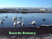
The Estuary has long been famous for its beautiful mute Swans, and Light-bellied Brent Geese are so numerous on the Swords Estuary as to be of international importance.
Environmental Impact Study
The Environmental Impact Study concluded that once the bridge was constructed, it should have little or no effect on aquatic or avian life, and that the most serious effects would be during the construction process. This is self-evident at present, and it is to be hoped that the conclusions which were arrived at in the report are borne out, otherwise, a natural resource of great importance and beauty will have been destroyed.
Fauna
Among the amphibians and mammals are frogs, rabbits, hares, wood-mice, bats and hedgehogs.
Habitats
There are many significant habitats in this area, and the wetlands are of considerable importance because they could contain protected species. The biggest impact of the motorway will be with regard to the loss of hedgerows (about 12,000 metres in total), and there is the ever-present risk during construction of water pollution which could have disastrous consequences for aquatic life.
Other Effects
Effects such as noise, air quality and vibration cannot be quantified until the bridge is built, but there is a recommendation that a noise barrier be erected along the length of the motorway at the Broadmeadow estuary crossing. Apart from the noise and disruption to the area, the most obvious impact will be visual. The Report simply suggests that the visual impact of the proposed bridge will be less severe than any of the alternatives, but this does not answer the question with regard to actual visual impact. There is a recommendation that trees be retained at Lissenhall, at Hutchinson’s Strand Lane, and that the embankments be landscaped.
Prospect Point
On the other side of the new bridge, we come to Prospect Point (former stables of Lissenhall House) which overlooks the Estuary at the north entrance. The estuary widens appreciably at this point, and Malahide is clearly visible across the sea. This inlet was known as Inver Donan (Donan was one of the gods of the Fir Donan tribe who were related to the Fir Bolg).
Seatown Castle
Across the water can be seen the ruins of Seatown Castle, the home of the Dickie family for many years. [The castle was roofed and now acts as a barn. Seatown Castle was built by the Russell family about 1500].
The Viaduct
The viaduct consisting of 12 arches was built in the 1840s to enable the trains to cross the sea on their journeys from Dublin to Belfast. After Prospect Point, the next town land is called Newport, and there is then a road to the left leading to Ballymadrough (Bealach M’Eadróg, the pass of Eder). The Seafield demesne is on the right, and this was formerly the home of Squire Arthurs, the man who opened the copper mines in Loughshinny. On the opposite side of the inlet is the road to Malahide. This was the original road to Malahide. The present day Swords to Malahide Road was built by the Talbot family of Malahide.
The Estuary
This area around the Estuary has long been a favourite walk for the people of Swords because of its tranquillity and great natural beauty. Parents have brought their children to the Estuary to feed the swans, and to admire the splendid views of the birds, the sea and Malahide. It is to be hoped that this area will continue to be available to the people of Swords, and that it will not be destroyed in the quest for progress.